


Current Watches, Warnings and Advisories for Colorado
Updated: 5 weeks 6 days ago
Dense Fog Advisory issued February 5 at 5:57AM MST until February 5 at 11:00AM MST by NWS Denver CO
* WHAT...Visibility down to just a few hundred feet in spots.
* WHERE...Greeley and the central and southwest portions of Weld
County.
* WHEN...Until 11 AM MST this morning.
* IMPACTS...Low visibility will make driving conditions hazardous.
Be prepared for slow travel conditions and allow plenty of time to
reach your destination safely.
Dense Fog Advisory
2024-02-05T05:57:00-07:00
2024-02-05T05:57:00-07:00
2024-02-05T05:57:00-07:00
2024-02-05T11:00:00-07:00
Actual
Update
Met
Expected
Moderate
Likely
Central and South Weld County
SAME
008123
UGC
COZ043
AWIPSidentifier
NPWBOU
WMOidentifier
WWUS75 KBOU 051257
NWSheadline
DENSE FOG ADVISORY REMAINS IN EFFECT UNTIL 11 AM MST THIS MORNING
BLOCKCHANNEL
EAS
BLOCKCHANNEL
NWEM
BLOCKCHANNEL
CMAS
VTEC
/O.CON.KBOU.FG.Y.0006.000000T0000Z-240205T1800Z/
eventEndingTime
2024-02-05T18:00:00+00:00
Winter Storm Watch issued February 5 at 3:47AM MST until February 8 at 5:00PM MST by NWS Pueblo CO
* WHAT...Heavy snow possible. Total snow accumulations of 8 to 36
inches possible. Winds could gust as high as 50 mph.
* WHERE...La Garita Mountains above 10000 feet and Eastern San
Juan Mountains above 10000 feet.
* WHEN...From Tuesday morning through Thursday afternoon.
* IMPACTS...Travel could be very difficult to impossible. Patchy
blowing snow could significantly reduce visibility. The
hazardous conditions could impact the morning or evening
commute. Gusty winds could bring down tree branches.
Winter Storm Watch
2024-02-05T03:47:00-07:00
2024-02-05T03:47:00-07:00
2024-02-06T11:00:00-07:00
2024-02-05T15:30:00-07:00
Actual
Alert
Met
Future
Severe
Possible
La Garita Mountains Above 10000 Ft; Eastern San Juan Mountains Above 10000 Ft
SAME
008079
SAME
008105
SAME
008109
SAME
008021
UGC
COZ066
UGC
COZ068
AWIPSidentifier
WSWPUB
WMOidentifier
WWUS45 KPUB 051047
NWSheadline
WINTER STORM WATCH IN EFFECT FROM TUESDAY MORNING THROUGH THURSDAY AFTERNOON
BLOCKCHANNEL
EAS
BLOCKCHANNEL
NWEM
BLOCKCHANNEL
CMAS
EAS-ORG
WXR
VTEC
/O.NEW.KPUB.WS.A.0008.240206T1800Z-240209T0000Z/
eventEndingTime
2024-02-09T00:00:00+00:00
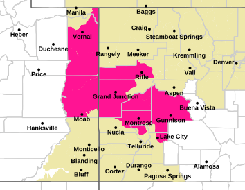
Winter Storm Watch issued February 5 at 1:56AM MST until February 8 at 6:00PM MST by NWS Grand Junction CO
* WHAT...Heavy snow possible above 7500 feet. Total snow
accumulations of 10 to 20 inches possible. Winds could gust as
high as 50 mph.
* WHERE...Grand and Battlement Mesas and Uncompahgre Plateau and
Dallas Divide.
* WHEN...From Tuesday evening through Thursday afternoon.
* IMPACTS...Travel could be very difficult. Blowing snow could
significantly reduce visibility, especially on ridge tops. A
detailed map of the snowfall can be found at:
www.weather.gov/gjt/winter.
Winter Storm Watch
2024-02-05T01:56:00-07:00
2024-02-05T01:56:00-07:00
2024-02-06T18:00:00-07:00
2024-02-05T16:00:00-07:00
Actual
Alert
Met
Future
Severe
Possible
Grand and Battlement Mesas; Uncompahgre Plateau/Dallas Divide
SAME
008029
SAME
008045
SAME
008077
SAME
008085
SAME
008091
SAME
008113
UGC
COZ009
UGC
COZ017
AWIPSidentifier
WSWGJT
WMOidentifier
WWUS45 KGJT 050856
NWSheadline
WINTER STORM WATCH IN EFFECT FROM TUESDAY EVENING THROUGH THURSDAY AFTERNOON ABOVE 7500 FEET
BLOCKCHANNEL
EAS
BLOCKCHANNEL
NWEM
BLOCKCHANNEL
CMAS
EAS-ORG
WXR
VTEC
/O.NEW.KGJT.WS.A.0005.240207T0100Z-240209T0100Z/
eventEndingTime
2024-02-09T01:00:00+00:00
Winter Storm Watch issued February 5 at 1:56AM MST until February 8 at 6:00PM MST by NWS Grand Junction CO
* WHAT...Heavy snow possible. Total snow accumulations of 1 to 2
feet possible. Winds could gust as high as 50 mph.
* WHERE...Northwest San Juan Mountains and Southwest San Juan
Mountains.
* WHEN...From Tuesday afternoon through Thursday afternoon.
* IMPACTS...Travel could be very difficult to impossible. Areas of
blowing snow could significantly reduce visibility. A detailed
map of the snowfall can be found at: www.weather.gov/gjt/winter.
Winter Storm Watch
2024-02-05T01:56:00-07:00
2024-02-05T01:56:00-07:00
2024-02-06T12:00:00-07:00
2024-02-05T16:00:00-07:00
Actual
Alert
Met
Future
Severe
Possible
Northwestern San Juan Mountains; Southwest San Juan Mountains
SAME
008051
SAME
008053
SAME
008085
SAME
008091
SAME
008113
SAME
008007
SAME
008033
SAME
008067
SAME
008083
SAME
008111
UGC
COZ018
UGC
COZ019
AWIPSidentifier
WSWGJT
WMOidentifier
WWUS45 KGJT 050856
NWSheadline
WINTER STORM WATCH IN EFFECT FROM TUESDAY AFTERNOON THROUGH THURSDAY AFTERNOON
BLOCKCHANNEL
EAS
BLOCKCHANNEL
NWEM
BLOCKCHANNEL
CMAS
EAS-ORG
WXR
VTEC
/O.NEW.KGJT.WS.A.0005.240206T1900Z-240209T0100Z/
eventEndingTime
2024-02-09T01:00:00+00:00
Winter Storm Warning issued January 07 at 10:45PM MST until January 08 at 5:00AM MST by NWS
...WINTER STORM WARNING REMAINS IN EFFECT UNTIL 5 AM MST MONDAY... * WHAT...Heavy snow. Additional snow accumulations of up to 3 inches. Winds gusting as high as 45 mph. * WHERE...In Colorado, Roan and Tavaputs Plateaus. In Utah, Tavaputs Plateau. * WHEN...Until 5 AM MST Monday.
Winter Storm Warning
2024-01-07T22:45:00-07:00
2024-01-08T05:00:00-07:00
Actual
Alert
Met
Expected
Moderate
Likely
Roan and Tavaputs Plateaus
FIPS6
008045 008103
UGC
COZ003
VTEC
/O.CON.KGJT.WS.W.0001.000000T0000Z-240108T1200Z/
Winter Storm Warning issued January 07 at 10:45PM MST until January 08 at 5:00AM MST by NWS
...WINTER STORM WARNING REMAINS IN EFFECT UNTIL 5 AM MST MONDAY... * WHAT...Heavy snow. Additional snow accumulations of up to 5 inches. * WHERE...Grand and Battlement Mesas. * WHEN...Until 5 AM MST Monday. * IMPACTS...Plan on slippery road conditions. A detailed map of
Winter Storm Warning
2024-01-07T22:45:00-07:00
2024-01-08T05:00:00-07:00
Actual
Alert
Met
Expected
Moderate
Likely
Grand and Battlement Mesas
FIPS6
008029 008077
UGC
COZ009
VTEC
/O.CON.KGJT.WS.W.0001.000000T0000Z-240108T1200Z/
Winter Storm Warning issued January 07 at 10:45PM MST until January 08 at 5:00AM MST by NWS
...WINTER STORM WARNING REMAINS IN EFFECT UNTIL 5 AM MST MONDAY... * WHAT...Heavy snow. Additional snow accumulations of up to 3 inches. Winds gusting as high as 40 mph. * WHERE...Uncompahgre Plateau and Dallas Divide. * WHEN...Until 5 AM MST Monday. * IMPACTS...Plan on slippery road conditions. Patchy blowing
Winter Storm Warning
2024-01-07T22:45:00-07:00
2024-01-08T05:00:00-07:00
Actual
Alert
Met
Expected
Moderate
Likely
Uncompahgre Plateau, Dallas Divide
FIPS6
008077 008085 008091
UGC
COZ017
VTEC
/O.CON.KGJT.WS.W.0001.000000T0000Z-240108T1200Z/
Winter Storm Warning issued January 07 at 10:45PM MST until January 08 at 5:00AM MST by NWS
...WINTER STORM WARNING REMAINS IN EFFECT UNTIL 5 AM MST MONDAY... * WHAT...Heavy snow. Additional snow accumulations of up to 3 inches. Winds gusting as high as 40 mph. * WHERE...Four Corners/Upper Dolores River. * WHEN...Until 5 AM MST Monday. * IMPACTS...Plan on slippery road conditions. Patchy blowing
Winter Storm Warning
2024-01-07T22:45:00-07:00
2024-01-08T05:00:00-07:00
Actual
Alert
Met
Expected
Moderate
Likely
Four Corners, Upper Dolores River
FIPS6
008033 008083
UGC
COZ021
VTEC
/O.CON.KGJT.WS.W.0001.000000T0000Z-240108T1200Z/
Winter Storm Warning issued January 07 at 10:45PM MST until January 08 at 5:00AM MST by NWS
...WINTER STORM WARNING REMAINS IN EFFECT UNTIL 5 AM MST MONDAY... * WHAT...Heavy snow. Additional snow accumulations of up to 3 inches. * WHERE...Animas River Basin and San Juan River Basin. * WHEN...Until 5 AM MST Monday. * IMPACTS...Plan on slippery road conditions. A detailed map of
Winter Storm Warning
2024-01-07T22:45:00-07:00
2024-01-08T05:00:00-07:00
Actual
Alert
Met
Expected
Moderate
Likely
Animas River Basin; San Juan River Basin
FIPS6
008007 008067
UGC
COZ022 COZ023
VTEC
/O.CON.KGJT.WS.W.0001.000000T0000Z-240108T1200Z/
Winter Weather Advisory issued January 07 at 10:45PM MST until January 08 at 5:00AM MST by NWS
...WINTER WEATHER ADVISORY REMAINS IN EFFECT UNTIL 5 AM MST MONDAY... * WHAT...Snow. Additional snow accumulations of up to 2 inches. * WHERE...West Elk and Sawatch Mountains. * WHEN...Until 5 AM MST Monday. * IMPACTS...Plan on slippery road conditions. The cold wind
Winter Weather Advisory
2024-01-07T22:45:00-07:00
2024-01-08T05:00:00-07:00
Actual
Alert
Met
Expected
Minor
Likely
West Elk and Sawatch Mountains
FIPS6
008051
UGC
COZ012
VTEC
/O.CON.KGJT.WW.Y.0002.000000T0000Z-240108T1200Z/
Winter Weather Advisory issued January 07 at 10:45PM MST until January 08 at 5:00AM MST by NWS
...WINTER WEATHER ADVISORY REMAINS IN EFFECT UNTIL 5 AM MST MONDAY... * WHAT...Snow. Additional snow accumulations of up to 3 inches. Winds gusting as high as 45 mph. * WHERE...Paradox Valley/Lower Dolores River. * WHEN...Until 5 AM MST Monday.
Winter Weather Advisory
2024-01-07T22:45:00-07:00
2024-01-08T05:00:00-07:00
Actual
Alert
Met
Expected
Minor
Likely
Paradox Valley, Lower Dolores River
FIPS6
008085 008113
UGC
COZ020
VTEC
/O.CON.KGJT.WW.Y.0002.000000T0000Z-240108T1200Z/
Winter Storm Warning issued January 07 at 10:45PM MST until January 08 at 8:00AM MST by NWS
...WINTER STORM WARNING REMAINS IN EFFECT UNTIL 8 AM MST MONDAY... * WHAT...Heavy snow. Additional snow accumulations of up to 4 inches. Winds gusting as high as 40 mph. * WHERE...Southwest San Juan Mountains. * WHEN...Until 8 AM MST Monday. * IMPACTS...Plan on slippery road conditions. Patchy blowing
Winter Storm Warning
2024-01-07T22:45:00-07:00
2024-01-08T08:00:00-07:00
Actual
Alert
Met
Expected
Moderate
Likely
Southwest San Juan Mountains
FIPS6
008007 008033 008053 008067 008083 008111
UGC
COZ019
VTEC
/O.CON.KGJT.WS.W.0001.000000T0000Z-240108T1500Z/
Winter Weather Advisory issued January 07 at 10:45PM MST until January 08 at 11:00AM MST by NWS
...WINTER WEATHER ADVISORY REMAINS IN EFFECT UNTIL 11 AM MST MONDAY... * WHAT...Snow. Additional snow accumulations of 4 to 8 inches. * WHERE...Northwest San Juan Mountains. * WHEN...Until 11 AM MST Monday. * IMPACTS...Plan on slippery road conditions. Patchy blowing
Winter Weather Advisory
2024-01-07T22:45:00-07:00
2024-01-08T11:00:00-07:00
Actual
Alert
Met
Expected
Minor
Likely
Northwestern San Juan Mountains
FIPS6
008051 008053 008091 008113
UGC
COZ018
VTEC
/O.CON.KGJT.WW.Y.0002.000000T0000Z-240108T1800Z/
High Wind Warning issued January 07 at 10:23PM MST until January 08 at 5:00PM MST by NWS
...HIGH WIND WARNING REMAINS IN EFFECT FROM 5 AM TO 5 PM MST MONDAY... * WHAT...North winds 35 to 45 mph with gusts of 60 to 70 mph expected. * WHERE...Southern El Paso County, Pueblo County, Crowley County, and Otero County.
High Wind Warning
2024-01-08T05:00:00-07:00
2024-01-08T17:00:00-07:00
Actual
Alert
Met
Expected
Severe
Likely
Colorado Springs Vicinity, Southern El Paso County, Rampart Range Below 7400 Ft; Crowley County; La Junta Vicinity, Otero County; Pueblo Vicinity, Pueblo County Below 6300 Feet
FIPS6
008025 008041 008089 008101
UGC
COZ085 COZ086 COZ089 COZ093
VTEC
/O.CON.KPUB.HW.W.0001.240108T1200Z-240109T0000Z/
Winter Weather Advisory issued January 07 at 10:18PM MST until January 08 at 5:00AM MST by NWS
...WINTER WEATHER ADVISORY REMAINS IN EFFECT UNTIL 5 AM MST MONDAY... * WHAT...Snow. Additional snow accumulations of 1 to 3 inches. * WHERE...Eastern Sawatch Mountains Above 11000 Feet and La Garita Mountains Above 10000 Feet. * WHEN...Until 5 AM MST Monday.
Winter Weather Advisory
2024-01-07T22:18:00-07:00
2024-01-08T05:00:00-07:00
Actual
Alert
Met
Expected
Minor
Likely
Eastern Sawatch Mountains above 11000 Ft; La Garita Mountains Above 10000 Ft
FIPS6
008015 008065 008079 008109
UGC
COZ060 COZ066
VTEC
/O.CON.KPUB.WW.Y.0002.000000T0000Z-240108T1200Z/
Winter Storm Warning issued January 07 at 10:18PM MST until January 08 at 8:00AM MST by NWS
...WINTER STORM WARNING REMAINS IN EFFECT UNTIL 8 AM MST MONDAY... * WHAT...Heavy snow. Additional snow accumulations of 3 to 8 inches. Winds gusting as high as 40 mph. * WHERE...Eastern San Juan Mountains Above 10000 Feet. * WHEN...Until 8 AM MST Monday. * IMPACTS...Travel could be very difficult. Widespread blowing
Winter Storm Warning
2024-01-07T22:18:00-07:00
2024-01-08T08:00:00-07:00
Actual
Alert
Met
Expected
Moderate
Likely
Eastern San Juan Mountains Above 10000 Ft
FIPS6
008021 008079 008105
UGC
COZ068
VTEC
/O.CON.KPUB.WS.W.0001.000000T0000Z-240108T1500Z/
Winter Storm Warning issued January 07 at 10:18PM MST until January 08 at 2:00PM MST by NWS
...WINTER STORM WARNING REMAINS IN EFFECT UNTIL 2 PM MST MONDAY... * WHAT...Snow expected. Total snow accumulations of 2 to 6 inches...with the highest amounts near and just south the Palmer Divide. Winds gusting as high as 65 mph. * WHERE...Northern El Paso County. * WHEN...From midnight tonight to 2 PM MST Monday.
Winter Storm Warning
2024-01-08T00:00:00-07:00
2024-01-08T14:00:00-07:00
Actual
Alert
Met
Expected
Moderate
Likely
Northern El Paso County, Monument Ridge, Rampart Range Below 7500 Ft
FIPS6
008041
UGC
COZ084
VTEC
/O.CON.KPUB.WS.W.0001.240108T0700Z-240108T2100Z/
Winter Weather Advisory issued January 07 at 10:18PM MST until January 08 at 2:00PM MST by NWS
...WINTER WEATHER ADVISORY REMAINS IN EFFECT UNTIL 2 PM MST MONDAY... * WHAT...Snow. Additional snow accumulations of 3 to 8 inches. Winds gusting as high as 45 mph. * WHERE...Northern Sangre de Cristo Mountains. * WHEN...Until 2 PM MST Monday.
Winter Weather Advisory
2024-01-07T22:18:00-07:00
2024-01-08T14:00:00-07:00
Actual
Alert
Met
Expected
Minor
Likely
Northern Sangre de Cristo Mountains Between 8500 And 11000 Ft; Northern Sangre de Cristo Mountains above 11000 Ft
FIPS6
008027 008055 008109
UGC
COZ072 COZ073
VTEC
/O.CON.KPUB.WW.Y.0002.000000T0000Z-240108T2100Z/
Winter Weather Advisory issued January 07 at 10:18PM MST until January 08 at 2:00PM MST by NWS
...WINTER WEATHER ADVISORY REMAINS IN EFFECT UNTIL 2 PM MST MONDAY... * WHAT...Snow expected. Total snow accumulations 3 to 7 inches. Winds gusting as high as 50 mph. * WHERE...Teller County and the Rampart Range. * WHEN...From 9 PM this evening to 2 PM MST Monday.
Winter Weather Advisory
2024-01-07T22:18:00-07:00
2024-01-08T14:00:00-07:00
Actual
Alert
Met
Expected
Minor
Likely
Pikes Peak above 11000 Ft; Teller County, Rampart Range above 7500fT, Pike's Peak Between 7500 And 11000 Ft
FIPS6
008041 008119
UGC
COZ081 COZ082
VTEC
/O.CON.KPUB.WW.Y.0002.000000T0000Z-240108T2100Z/
Winter Weather Advisory issued January 07 at 10:18PM MST until January 08 at 2:00PM MST by NWS
...WINTER WEATHER ADVISORY REMAINS IN EFFECT UNTIL 2 PM MST MONDAY... * WHAT...Snow expected. Total snow accumulations of 3 to 8 inches. Winds gusting as high as 40 mph. * WHERE...Wet Mountains. * WHEN...From 11 PM this evening to 2 PM MST Monday.
Winter Weather Advisory
2024-01-07T23:00:00-07:00
2024-01-08T14:00:00-07:00
Actual
Alert
Met
Expected
Minor
Likely
Wet Mountains above 10000 Ft; Wet Mountains between 6300 and 10000Ft
FIPS6
008027 008055 008101
UGC
COZ079 COZ080
VTEC
/O.CON.KPUB.WW.Y.0002.240108T0600Z-240108T2100Z/
CO/WY WEATHER


Who's Online
There are currently 0 users and 122 guests online.